Choosing the best volcanic cliff hike isn’t about finding the prettiest island, but understanding the geological forces that shape your adventure.
- Massive, sheer cliffs are born from hard basalt rock resisting erosion, a feature coral atolls fundamentally lack.
- Trail infrastructure varies dramatically between Atlantic islands (often EU-funded) and the wilder, community-maintained paths of the Pacific.
Recommendation: Prioritise your hike based on geological stability and safety infrastructure, not just social media fame.
The image is iconic: a lone hiker silhouetted against the sky, standing atop a colossal cliff plunging into a churning sea. For adventure travellers and geology enthusiasts, this is the pinnacle of natural drama. Many immediately think of the whitewashed villages of Santorini or the lush pali of Hawaii. The internet is flooded with lists of beautiful islands, often accompanied by generic advice to « wear good shoes » and « bring plenty of water. » While well-intentioned, this barely scratches the surface of what it means to truly and safely experience these magnificent landscapes.
But what if the key to unlocking the most rewarding and secure cliff hiking experience wasn’t in a ‘Top 10’ list, but in understanding the very geological DNA of the island beneath your feet? The real difference between a thrilling trek and a perilous misstep lies in appreciating the forces at play—from the structural integrity of friable basalt to the intense heat radiating from a dark scree slope under the midday sun. This perspective transforms a simple hike into a conversation with the planet itself.
This guide moves beyond the picturesque to the practical. We’ll dissect why volcanic islands create such superior cliffs, explore the crucial differences in trail infrastructure between the Atlantic and Pacific, and equip you with specific, geology-informed safety protocols. By understanding the ‘why’ behind the view, you can choose and conquer the world’s most spectacular volcanic cliffs with both awe and confidence.
To navigate this geological and adventurous journey, here is a breakdown of the critical topics we will cover. Each section is designed to build your expertise, ensuring your next cliff-side expedition is as safe as it is breathtaking.
Summary: A Geotourist’s Guide to Volcanic Coastal Treks
- Why Do Volcanic Islands Have More Dramatic Coastal Cliffs Than Coral Atolls?
- Why Do Volcanic Islands Have Black Sand Beaches Beneath Their Coastal Cliffs?
- Why Do Volcanic Crater Treks Demand More Fitness Than Standard Hikes of Equal Distance?
- Atlantic Volcanic Islands or Pacific for Cliff Hiking: Which Has Better Trail Infrastructure?
- How to Prepare for Trekking Active Volcanic Craters Safely on Island Expeditions?
- How to Hike Volcanic Cliff Paths Safely Without Hiring Professional Guides?
- When Should You Hike Volcanic Island Cliffs: Morning Clarity or Afternoon Light?
- The Cliff Edge Photography Risk That Causes Multiple Island Tourist Deaths Each Year
Why Do Volcanic Islands Have More Dramatic Coastal Cliffs Than Coral Atolls?
The fundamental difference lies in their birth and composition. Volcanic islands are built from the ground up by additive geological processes. When magma erupts, it creates new land, often forming steep-sided cones and massive shields. The rock itself, typically basalt, is the key to forming dramatic cliffs. As geological research confirms, basalt is significantly harder and more resistant to erosion than the calcium carbonate of coral limestone. This hardness allows it to maintain near-vertical faces even when relentlessly battered by ocean waves.
In contrast, coral atolls are formed by slow, biological accumulation at or near sea level. They are the skeletons of tiny marine organisms, resulting in low-lying islands that rarely rise more than a few meters above the water. Their limestone base is soft and porous, crumbling easily under wave action rather than standing firm. They simply lack the initial verticality and the material strength to form towering cliffs.
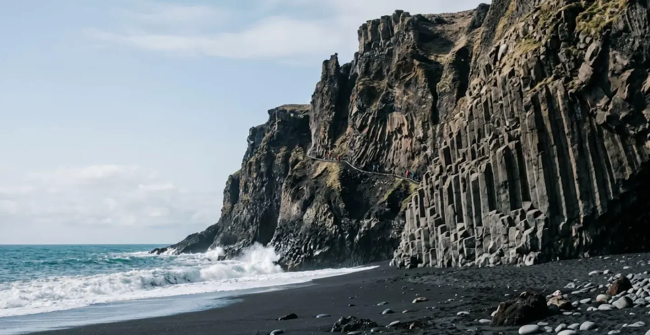
A prime example of volcanic cliff formation is Reynisfjara Beach in Iceland. Its famous towering basalt columns and jagged sea stacks are the direct result of lava cooling rapidly. This process creates immense vertical structures that define the coastline’s dramatic character. This constant geological activity, an additive process, is something a coral atoll, formed by a slow, organic process, can never replicate. The power of a volcano builds mountains; the patience of coral builds reefs. For sheer, breathtaking cliffs, the explosive power of volcanism is unbeatable.
Why Do Volcanic Islands Have Black Sand Beaches Beneath Their Coastal Cliffs?
The iconic black sand beaches found at the base of many volcanic cliffs are a direct and dramatic byproduct of the island’s creation. They are not made of the typical quartz or shell fragments found on white beaches. Instead, this dark sand is composed almost entirely of weathered volcanic rock, primarily basalt and other iron-rich minerals. The formation process is a testament to nature’s raw power.
The most common mechanism occurs when a molten lava flow reaches the cold ocean. The immense temperature difference creates a phenomenon known as thermal shock. This shock is so violent that it instantly shatters the hot basalt into tiny fragments of sand and rock. Over time, the relentless action of waves and currents grinds these fragments down further into the fine, dark sand that carpets the shoreline. This process is continuous on active volcanic islands, where fresh lava flows periodically replenish the supply of black sand.
Punalu’u Beach on Hawaii’s Big Island is a world-famous example of this process in action. The beach is made of basaltic sand created by lava from nearby volcanoes meeting the sea. A key characteristic of these beaches, due to the high iron content of the minerals, is their ability to absorb and radiate heat. A black sand beach under the tropical sun can become scorching hot, a practical consideration for any visitor. So, when you see a black sand beach, you’re not just looking at unique sand; you’re standing on the shattered, wave-worn remnants of a fiery volcanic eruption.
Why Do Volcanic Crater Treks Demand More Fitness Than Standard Hikes of Equal Distance?
A ten-kilometre hike is not always a ten-kilometre hike. When trekking on a volcanic crater, the terrain itself becomes a primary source of exertion, demanding significantly more physical fitness than a standard trail of the same length. The reason lies in the unstable and challenging surfaces created by volcanic activity. Unlike a packed-earth forest path, crater trails are often composed of loose materials like scree, tephra (volcanic ash), and cinder.
Every step on this type of ground requires extra effort. Your feet sink, the ground shifts, and your leg muscles must constantly work to stabilize your body and prevent you from sliding backward. According to volcanic hiking experts who note that walking on loose surfaces requires 1.5 to 2 times more energy than walking on a solid path. This is because you are not just propelling yourself forward; you are effectively lifting your leg out of a small hole with every step, fighting a micro-landslide that tries to pull you down.
Furthermore, crater hikes often involve sustained, steep ascents and descents with few flat sections for recovery. The combination of a steep gradient and an unstable surface creates a formidable challenge for your cardiovascular system and leg muscles, particularly your quadriceps and calves. The constant stabilization effort can lead to muscle fatigue much faster than on a solid trail, making a seemingly short hike feel like a marathon.
Atlantic Volcanic Islands or Pacific for Cliff Hiking: Which Has Better Trail Infrastructure?
When choosing a volcanic island for cliff hiking, the ocean it sits in can tell you a lot about the experience you’ll likely have. The difference in trail infrastructure between the Atlantic and Pacific volcanic islands is often stark, shaped by distinct histories, funding sources, and geological origins. As a recent comparative analysis shows, there’s a clear divergence in character.
| Feature | Atlantic Islands (Azores, Madeira, Canaries) | Pacific Islands (Hawaii, Samoa, Vanuatu) |
|---|---|---|
| Funding Source | EU regional development funding | National park systems, community-maintained |
| Trail Character | Well-maintained stone-paved paths, repurposed agricultural routes (levadas, caminos reales) | More rugged, wild experience, variable maintenance |
| Geological Origin | Mid-Atlantic Ridge volcanism (Iceland, Azores, Canaries rise from Ridge) | Hot spot volcanism (Hawaiian-Emperor chain spans 6,000 km) |
| Signage & Amenities | Clear signage, regulated EU access standards | Variable, depends on national/state/indigenous land regulations |
| Best For | Comfort explorers seeking clear routes and facilities | Rugged individualists prioritizing solitude and challenge |
In the Atlantic, islands like Madeira, the Azores, and the Canary Islands benefit significantly from EU regional development funding. This has led to the creation and meticulous maintenance of extensive trail networks. Many of these trails are not just for tourism; they are repurposed historical routes like the famous stone-paved levadas in Madeira or the caminos reales (royal roads) in the Canaries. The result is a network of well-marked, often paved or cobbled paths with clear signage and regulated access, making them ideal for hikers who value comfort and clear navigation.
The Pacific offers a different proposition. Islands born from hot spot volcanism, like the Hawaiian chain, often feature a wilder, more rugged trail experience. While major routes within national parks are well-managed, many other trails are community-maintained and can vary greatly in condition. This can mean a more authentic and challenging adventure, often with greater solitude. However, it also requires a higher degree of self-reliance, as signage can be inconsistent and amenities sparse. The choice, therefore, is not about which is « better, » but about what kind of adventurer you are.
How to Prepare for Trekking Active Volcanic Craters Safely on Island Expeditions?
Trekking an active volcanic crater is an entirely different undertaking from a standard mountain hike. The environment is dynamic, unpredictable, and potentially lethal. Preparation is not just a good idea; it is a critical survival protocol. As the safety documentation for Italy’s Stromboli volcano starkly warns, even on well-monitored volcanoes, the risk is real. The guide notes that on Stromboli, « In 2019, a sudden eruption killed one hiker and hurt several others. » This underscores the need for meticulous preparation.
Your safety plan should include several non-negotiable elements. Before you even pack your bag, your first step must be intelligence gathering. Check the official Volcanic Alert Levels (often a color-coded system from Green to Red) provided by the region’s government geological survey. High levels of activity will almost always result in summit access being restricted.
Your gear must also be specialized for the unique hazards of a volcanic environment. Beyond standard hiking equipment, consider these essentials:
- Specialized Gear: Pack a respirator mask or a damp cloth to protect against sulfur dioxide and fine ash. Choose sturdy leather boots, as the synthetics in lighter boots can melt on unexpectedly hot ground. Wrap-around sunglasses are crucial for protecting eyes from fine, abrasive volcanic particles blown by the wind.
- Geohazard Escape Route: Before you ascend, pre-plan a rapid exit route. This should be away from the prevailing wind direction to help you escape sudden increases in fumarole activity (gas vents) or a phreatic (steam-driven) eruption.
- Communication Contingency: Active craters are often remote with poor or non-existent cell service. Carry a satellite communication device like a Garmin InReach or a Personal Locator Beacon (PLB) for emergencies.
- Emergency Awareness: Familiarize yourself with any local acoustic warning systems. In many volcanic areas, sirens indicate an imminent eruption or a tsunami risk if lava is flowing into the sea.
Finally, honestly assess your physical fitness for a sustained, steep ascent and descent, often at moderate to high altitudes where oxygen is less available. An active crater is no place to discover your physical limits.
How to Hike Volcanic Cliff Paths Safely Without Hiring Professional Guides?
Embarking on a volcanic cliff hike without a professional guide requires a heightened sense of personal responsibility and a robust understanding of the specific risks involved. While guides provide invaluable local knowledge, a well-prepared hiker can mitigate many dangers through diligent planning and disciplined execution. The key is to shift your mindset from that of a tourist to that of an expedition member, where you are solely responsible for your own safety.
The ground beneath your feet on a volcanic cliff is not as stable as a typical mountain trail. The rock can be friable and brittle, and what appears to be a solid path can conceal deep, shadowed cracks or sit atop an unstable overhang. Sticking to clearly marked trails is not just advice; it’s a critical rule for survival. The image below illustrates the careful, tactile assessment needed when interacting with this type of terrain.
To structure your independent hike safely, it’s essential to follow a systematic protocol before and during your trek. This checklist covers the absolute essentials for any unguided volcanic cliff hike.
Your Action Plan: Volcanic Cliff Hiking Safety Protocol
- Check volcanic alert levels and park conditions before departure – conditions can change without warning.
- Hike early in the morning before the sun reaches its peak strength, as lava rock radiates intense heat and most trails lack shade.
- Stay on marked trails at all times – lava rock is unstable and dangerous cracks and cliffs may be shadowed.
- Carry reliable communication devices as park staff coverage is often limited and cell service can be spotty.
- Watch for hazardous gases, especially if you have respiratory issues, and be aware of Pele’s hair (windblown volcanic glass).
Adhering to this protocol transforms your hike from a casual walk into a well-managed micro-expedition. It acknowledges the dynamic nature of the volcanic environment and prioritizes your well-being above all else, allowing you to focus on the spectacular beauty surrounding you.
When Should You Hike Volcanic Island Cliffs: Morning Clarity or Afternoon Light?
The timing of your volcanic cliff hike can dramatically alter your experience, influencing everything from your physical comfort and safety to the quality of your photographs. There is no single « best » time; instead, it’s a strategic choice between the advantages of the morning and the allure of the afternoon, each with its own set of risks and rewards.
The primary case for a morning ascent is built on safety and comfort. Temperatures are cooler, which is a crucial factor on trails dominated by dark, heat-radiating volcanic rock. Many of these cliff paths are exposed and lack shade, making a midday hike a grueling, dehydrating ordeal. An early start also means you’ll encounter fewer crowds and often enjoy clearer summit views before the common afternoon cloud buildup obscures the landscape. The main disadvantage of the morning is the light; harsh, high-overhead sun can create deep shadows that obscure potential path hazards like cracks or loose rocks.
Conversely, the afternoon hike is often pursued by photographers seeking the « golden hour. » The low-angle light in the late afternoon casts a warm, dramatic glow on the landscape, making the textures of the dark rock pop and creating breathtaking photo opportunities. However, this reward comes with increased risk. The accumulated heat of the day makes the rock surfaces intensely hot, increasing the danger of dehydration and heat exhaustion. Furthermore, afternoon weather can be less stable, with a higher chance of sudden wind or rain. The most critical risk is running out of daylight. A non-negotiable safety rule is to always calculate your turn-around time based on the clock, not distance, to ensure a safe return before sunset. Hiking on an unfamiliar volcanic trail after dark is exceptionally dangerous and should never be attempted.
Key Takeaways
- Volcanic basalt makes for steeper, more dramatic cliffs than coral limestone, creating superior hiking landscapes.
- Atlantic islands generally offer more developed and well-maintained trails due to EU funding, while Pacific islands provide a wilder, more rugged adventure.
- True hiking safety on volcanic cliffs goes beyond generic advice; it requires understanding specific geological hazards like unstable rock, heat radiation, and volcanic gasses.
The Cliff Edge Photography Risk That Causes Multiple Island Tourist Deaths Each Year
The desire to capture the perfect, vertigo-inducing photo from the edge of a spectacular cliff is a powerful and increasingly deadly impulse. In the age of social media, the pressure to get a unique shot often leads tourists to take extreme risks, with tragic consequences. This is not an anecdotal problem; it’s a documented global phenomenon. A study published in the Journal of Travel Medicine found 379 selfie-related deaths worldwide between 2008 and 2021, with falls from heights accounting for roughly half of all incidents.
The researchers were unequivocal about the primary cause, stating that « Tourists were most at risk, with the most common cause of death being falling from cliffs or waterfalls while attempting to take a selfie. » The focus on framing the shot, checking the screen, and adopting a pose fatally distracts from situational awareness. On a volcanic cliff, where the ground can be unstable and edges can crumble without warning, this momentary lapse in concentration can be the last one a person ever makes. No photograph is worth a life.
The solution is simple and absolute: respect designated viewpoints and barriers. These are not arbitrary suggestions; they are safety features installed by park authorities who understand the local geology and the hidden dangers of the terrain. A safe viewpoint, often set back several meters from the true edge, still provides a spectacular, awe-inspiring vista without requiring you to gamble with your life.
Enjoying the view from a secure, designated area allows you to fully immerse yourself in the grandeur of the landscape without the background anxiety of a precarious position. It’s a choice to prioritize your experience—and your life—over a fleeting digital image.
Plan your next great adventure by prioritizing geological understanding and on-the-ground safety over the perfect social media shot. Choose your island, study its geology, respect its power, and you will be rewarded with an experience that is not only spectacular but also something you will live to share.