Trekking an active volcano requires far more than standard hiking fitness; it demands a deep understanding of its invisible threats, from physiological stressors to geological instability.
- Volcanic environments uniquely deplete oxygen and expose you to toxic gases, demanding specific cardiovascular preparation.
- Superficial trail visibility is deceptive; professional guides are critical for interpreting real-time, unseen hazards like ground instability and gas pockets.
Recommendation: Prioritize verifying official volcanic activity levels and investing in a guide over assuming a visible trail equals a safe route.
The allure of standing on the rim of an active volcanic crater, gazing into the earth’s raw power, is an unparalleled experience for any adventure trekker. Many approach these expeditions with the mindset of a standard mountain hike, focusing on distance and elevation. They pack their best boots, check the weather forecast, and assume physical fitness is the primary key to success. This is a fundamental, and potentially dangerous, misunderstanding of the environment they are about to enter.
A volcanic landscape is not a static mountain. It’s a living, breathing entity governed by forces that are often invisible to the untrained eye. Standard hiking preparation addresses the visible challenges—the steepness of the path, the length of the trail. However, it fails to account for the unique physiological stressors, the atmospheric volatility, and the geological instability inherent to these locations. The real challenge isn’t just the climb; it’s navigating an environment where the ground beneath your feet can be unpredictable and the air you breathe can be compromised.
This guide moves beyond the basics. Instead of repeating generic advice, we will delve into the specific, often overlooked, dynamics of volcanic trekking. We will explore why your body reacts differently at volcanic altitudes, how to interpret official activity alerts like a professional, and why the gear you choose acts as a critical shield against unseen threats. The goal is to shift your preparation from simply conquering a trail to respectfully and safely navigating a powerful natural wonder. By understanding these underlying forces, you transform from a simple hiker into a well-prepared expedition member.
To navigate these complex environments safely, this guide is structured to build your expertise step-by-step. We will cover the specific fitness demands, how to verify activity, the optimal timing for your trek, essential gear, seasonal safety, and the critical role of professional guidance.
Summary: Volcanic Crater Trekking: Your Expert Guide to Safe Preparation on Island Expeditions
- Why Do Volcanic Crater Treks Demand More Fitness Than Standard Hikes of Equal Distance?
- How to Verify Current Volcanic Activity Levels Before Booking Crater Trek Tours?
- Sunrise Volcanic Crater Trek or Midday Ascent: Which for Best Conditions?
- The Volcanic Trek Mistake: Inadequate Gear for High-Altitude Temperature Extremes
- When Are Volcanic Crater Treks Safest: Seasonal Weather and Eruption Pattern Timing?
- How to Hike Volcanic Cliff Paths Safely Without Hiring Professional Guides?
- Why Do Volcanic Crater Treks Require Professional Guides Despite Visible Trails?
- Which Islands Have the Most Spectacular Volcanic Cliffs Accessible for Hiking?
Why Do Volcanic Crater Treks Demand More Fitness Than Standard Hikes of Equal Distance?
The assumption that a ten-mile hike is the same everywhere is a critical error in judgment when preparing for a volcanic crater. The physiological demands of a volcanic trek are substantially higher due to a combination of factors that go beyond simple elevation gain. The primary differentiator is the atmospheric composition. Volcanic areas, even during periods of low activity, release a steady stream of gases like sulfur dioxide. When combined with the fine, often abrasive, ash particles suspended in the air, breathing becomes more strenuous. Your respiratory system works harder to filter these elements, placing an additional tax on your energy reserves.
Furthermore, the effect of altitude is amplified. Standard altitude sickness is a known risk, but volcanic environments introduce additional stressors. A study on physiological responses during high-altitude volcanic hikes revealed a significantly higher cardiovascular load. For example, mean oxygen saturation drops to 80.2% during real altitude hiking at 4,205m, compared to 85.8% in simulated conditions without volcanic factors. This shows that the environment itself, not just the low oxygen pressure, impacts your body’s ability to perform.
This increased demand is quantifiable. The same study recorded the physiological responses of subjects during a 7-hour hike on Mauna Kea volcano. The real-world hike resulted in mean heart rates of 121 bpm, compared to just 103 bpm in a simulated chamber at the same altitude. This demonstrates that your heart works significantly harder to compensate for the combined effects of altitude, terrain, and atmospheric conditions. Therefore, your training must focus not just on endurance, but on high-intensity cardiovascular fitness to prepare for these amplified physiological stressors.
How to Verify Current Volcanic Activity Levels Before Booking Crater Trek Tours?
Relying on tour operators or anecdotal reports about a volcano’s status is insufficient. A core principle of expedition safety is proactive verification using official, scientific sources. Government geological surveys, such as the United States Geological Survey (USGS), provide real-time, data-driven alert systems that are the gold standard for risk assessment. Understanding how to read these systems is a non-negotiable skill for any prospective volcanic trekker. These are not general warnings; they are precise classifications of a volcano’s state, from its normal background rumblings to signs of an imminent hazardous eruption.
The first signs of a potential eruption that these agencies monitor include changes in seismic activity, ground deformation (swelling of the volcano’s surface), and variations in gas emissions. As a trekker, you won’t observe these signs directly, which is why consulting the official alert levels is paramount. For instance, the USGS uses a four-tiered system, from NORMAL to WARNING, which gives a clear indication of the potential danger. It’s crucial to check this system not just when you book, but continuously up to the day of your trek, as conditions can change rapidly.
This scientific monitoring is the backbone of your safety net. The data collected by sensors on the ground informs the alert levels and aviation color codes that can mean the difference between a successful trek and a life-threatening situation. Before entrusting your safety to any tour, you must perform your own due diligence.
Action Plan: Verifying Volcanic Activity with the USGS System
- Access Official Monitoring: Check the four-tiered alert system. This ranges from NORMAL (typical background, non-eruptive state) to WARNING (hazardous eruption is imminent, underway, or suspected).
- Verify Aviation Color Codes: Cross-reference the ground alert with the separate aviation code. These are GREEN (normal), YELLOW (exhibiting signs of elevated unrest), ORANGE (heightened unrest with increased potential of eruption), and RED (eruption is imminent or underway with significant emission of volcanic ash).
- Subscribe to Notifications: Use free services like the Volcano Notification Service (VNS) to receive real-time email alerts for specific volcanoes. This ensures you are immediately aware of any change in status.
- Check Monitoring Frequency: Before booking a trip to a less-known volcano, confirm it is actively monitored. The USGS, for instance, monitors 170 active US volcanoes, but the level of instrumentation can vary. Ensure your target is under vigilant watch.
Sunrise Volcanic Crater Trek or Midday Ascent: Which for Best Conditions?
Choosing between a pre-dawn start for a sunrise view and a more civilized midday ascent is a major decision in planning a volcanic trek, with significant implications for safety and experience. A sunrise trek, while offering spectacular « golden hour » photography, presents a unique set of challenges. It involves hiking in darkness, often in a crowded « headlamp highway » of fellow trekkers, and enduring the coldest temperatures at the summit while waiting for the sun. A delayed descent also means navigating treacherous terrain in the dark on tired legs, increasing the risk of falls.
A midday ascent avoids the pre-dawn cold and allows for more sleep, but it trades one set of risks for another. Midday is when convection-driven weather patterns are most active, leading to a higher likelihood of sudden cloud buildup, stronger winds, and afternoon storms. The intense sunlight can create harsh shadows, making photography difficult, and heat haze can reduce visibility. While the trail might be less crowded on the way up, you will be contending with descending crowds from the sunrise missions.
The choice ultimately depends on your priorities and tolerance for specific risks. The following comparison breaks down the key factors to help you make an informed decision based on weather, trail conditions, and safety considerations. No matter your choice, a dynamic risk assessment is crucial, as conditions can change without warning.
| Factor | Sunrise Trek (Pre-dawn Start) | Midday Ascent |
|---|---|---|
| Weather Stability | More stable atmospheric conditions, clearer views | Prone to convection-driven cloud buildup, stronger winds |
| Temperature Range | Extreme swings: freezing pre-dawn to intense midday heat | Warmer start but less dramatic temperature variation |
| Trail Traffic | Crowded ‘headlamp highway’, shared summit moment | More solitude but encounters with descending crowds |
| Photography Light | Dramatic golden hour, alpenglow, long shadows (requires high ISO) | Strong light reveals mineral colors but risks harsh shadows |
| Safety Considerations | Dark descent risk if delayed, colder summit exposure | Afternoon storm potential, reduced visibility from heat haze |
The Volcanic Trek Mistake: Inadequate Gear for High-Altitude Temperature Extremes
One of the most common and dangerous mistakes trekkers make is underestimating the violent temperature swings of a volcanic environment. You may start a hike in a warm, tropical climate at the base, only to face freezing winds and sub-zero temperatures at the crater rim just a few hours later. This is not standard mountain weather; it is amplified by high altitude, extreme wind exposure on barren slopes, and the potential for sudden, unpredictable weather changes. Your clothing is not just for comfort; it is a critical life-support system that must function as a shield against hypothermia and windburn.
The key to managing these extremes is a high-performance layering system. This approach allows you to adapt instantly by adding or removing layers to regulate your body temperature and manage moisture. The cardinal rule of this system is to completely avoid cotton. As Andes Trek Expeditions warns in their gear guide, « Clothes made from cotton should be avoided, since in wet conditions they absorb your body heat as they slowly dry out. » Cotton acts like a sponge, holding sweat against your skin and leading to rapid and dangerous heat loss when you stop moving or are exposed to wind.
Instead, your system must be built from synthetic or merino wool fabrics designed to wick moisture away from the skin. A proper 4-layer system provides the versatility needed to handle everything from an intense, sweaty ascent to a frigid, windy summit vigil.
- Layer 1 – Base Layer: Use a moisture-wicking synthetic or merino wool fabric. Its primary job is to pull sweat away from your skin to keep you dry.
- Layer 2 – Mid Layer: Add a lightweight fleece or an insulated jacket. This layer’s purpose is to trap air and provide insulation, retaining your body heat.
- Layer 3 – Shell Layer: Wear a windproof and waterproof outer shell. This is arguably the most crucial layer on a volcanic summit, as it blocks wind-driven ash and protects against sudden rain or snow.
- Layer 4 – Emergency Layer: Always pack a compressible, high-loft « puffy » jacket. This is your insurance policy for unexpected delays, extreme cold snaps, or an emergency bivouac.
When Are Volcanic Crater Treks Safest: Seasonal Weather and Eruption Pattern Timing?
Determining the safest time for a volcanic trek involves a dual analysis: assessing predictable seasonal weather patterns and understanding the less predictable nature of eruptive cycles. On the weather front, most volcanic regions have distinct wet and dry seasons. The dry season is almost always the safer and more pleasant option, offering clearer skies, more stable ground, and a lower risk of weather-related hazards like flash floods or lahars (volcanic mudflows). Planning your expedition during this window is the first layer of risk mitigation.
However, good weather does not eliminate geological risk. Volcanoes operate on their own timelines. While major eruptions are preceded by signs detected by monitoring agencies, smaller, more localized events can occur with less warning. This is why consulting official monitoring sources is a continuous process. It’s important to recognize the inherent danger; roughly half of the 170 young volcanoes in the United States are considered dangerous due to their eruptive history and proximity to communities. This statistic underscores that no active volcano is ever completely « safe. »
Interestingly, the time of year can even influence the impact of an eruption, adding another layer to safety considerations. A study modeling volcanic events showed that eruption seasonality significantly affects atmospheric outcomes. Research has demonstrated that eruptions in summer versus winter create distinct stratospheric plume patterns, with high-latitude winter eruptions having a more pronounced effect on atmospheric circulation. While this is a large-scale phenomenon, it highlights the complex, interconnected systems at play and reinforces the principle that timing your trek is a critical safety decision that goes beyond simply picking a sunny day.
How to Hike Volcanic Cliff Paths Safely Without Hiring Professional Guides?
While hiring a professional guide is unequivocally the safest way to trek a volcano, some experienced trekkers may choose to attempt marked trails on their own. This decision dramatically increases personal responsibility and requires an unwavering commitment to self-sufficiency and redundant safety systems. Your life depends entirely on your preparation, judgment, and the reliability of your equipment. The single most critical element for a solo trekker is a triple-redundancy navigation system, as GPS signals can be unreliable in remote canyons or during atmospheric disturbances.
This system ensures that if one method fails, you have immediate backups. It should consist of a primary dedicated GPS device, a smartphone with offline maps and a power bank, and the fundamental physical map and compass. Proficiency with the latter is non-negotiable; you must be able to navigate by terrain features and bearings if all electronics fail. Additionally, an emergency communication device like a satellite messenger is essential for check-ins and SOS capabilities in the no-service zones typical of volcanic landscapes.
Even with perfect navigation, the terrain itself presents constant, invisible threats. As the experts at Volcano Hiking Made Easy caution, « The summit crater edges can be unstable and slippery, requiring caution to prevent falls. Loose scree and volcanic ash increase the risk of slips and falls, particularly on steep sections. » Hiking without a guide means you are solely responsible for assessing this ground instability second-by-second. You lack the guide’s trained eye, which can spot subtle signs of a hazardous path that you might easily miss.
- System 1 – Dedicated GPS Device: Carry a robust GPS watch or handheld unit. These offer superior battery life and satellite reception compared to phones.
- System 2 – Smartphone Offline Maps: Use an app like AllTrails Pro or Gaia GPS with maps downloaded for offline use. Always carry a fully charged power bank.
- System 3 – Physical Backup: A printed topographic map of the area and a reliable compass are your ultimate fail-safe. You must have demonstrated proficiency in using them before you go.
- Emergency Communication: Pack a satellite messenger (e.g., Garmin inReach, Zoleo) for SOS functionality where there is no cellular service.
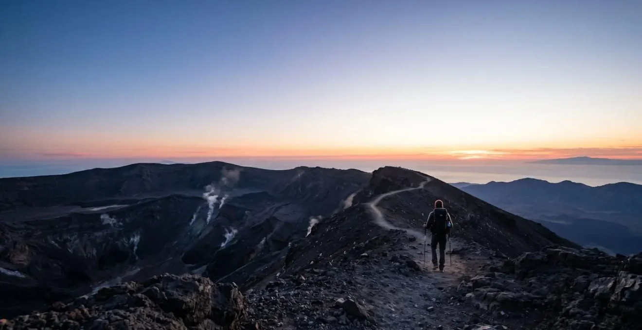
Why Do Volcanic Crater Treks Require Professional Guides Despite Visible Trails?
A clearly visible trail on a volcano can create a dangerous illusion of safety. It leads many trekkers to question the need for a guide, thinking, « How can I get lost if the path is right there? » This mindset misses the fundamental point: a guide’s primary role on a volcano is not to show you the way, but to act as a real-time, expert risk assessor for invisible threats. They are trained to interpret the subtle, dynamic language of the volcano—faint changes in the smell of gases, new cracks in the earth, or slight variations in fumarole activity—that an amateur would never notice.
This expertise is a literal lifesaver. A harrowing incident at the Nevados de Chillán volcano in Chile serves as a stark reminder. Tourists who bypassed guides to climb to the crater rim were caught in an unexpected eruption. As geophysicist Cristian Farías noted, they were in an « extremely hazardous place » with no adequate equipment, despite a 2km exclusion zone being in effect but not controlled. A professional guide would have never allowed them into that position, having the training to recognize the heightened risk and the authority to enforce a safe distance.
Case Study: The Nevados de Chillán Near-Miss
Tourists climbing the Nevados de Chillán volcano without guidance found themselves on the crater’s edge when it erupted unexpectedly. Video footage captured the terrifying moment as plumes of grey and black gas shot from the crater, completely engulfing the hikers. This incident highlights that a visible trail offers zero protection from sudden phreatic eruptions or toxic gas releases. The trekkers’ survival was a matter of sheer luck, not preparation. A guide’s expertise in risk zoning and interpreting subtle pre-eruptive signs would have prevented this near-fatal error.
This is why, in many high-risk areas, guides are not just recommended; they are mandatory. For example, at Rwanda’s Volcanoes National Park, authorities state clearly: « Guided hikes are mandatory, with professional park rangers accompanying all groups to ensure safety and environmental protection. » They understand that public safety in such a dynamic environment cannot be left to chance or amateur judgment. A guide is your most important piece of safety equipment.
Key Takeaways
- Volcanic trekking is fundamentally different from mountain hiking; it requires specific preparation for physiological stressors like toxic gases and reduced oxygen.
- Never rely on a visible trail as an indicator of safety. A professional guide’s main role is to assess invisible risks like ground instability and gas pockets.
- A multi-layer clothing system using synthetic or wool fabrics is critical. Avoid cotton at all costs, as it retains moisture and can lead to hypothermia.
Which Islands Have the Most Spectacular Volcanic Cliffs Accessible for Hiking?
Once you have mastered the principles of safe volcanic trekking, a world of breathtaking landscapes opens up. Islands, born from volcanic fire, often host some of the most dramatic and accessible volcanic cliffs and craters on the planet. These locations offer a perfect theater to apply your knowledge of safety protocols, from gear selection to reading the terrain. Each offers a unique blend of challenge, beauty, and a direct connection to the planet’s geological power.
From the lush montane forests that give way to stark volcanic terrain on Mount Bisoke in Rwanda to the iconic slopes of Mount Fuji in Japan, the options are as varied as they are spectacular. These are not just hikes; they are expeditions into primordial landscapes where every step is a reminder of the forces that shape our world. The Canary Islands, Hawaii, and Indonesia are other classic destinations, each with a roster of world-class volcanic treks that draw adventurers from across the globe.
Iconic Destination: Mount Teide, Tenerife, Spain
Rising to 3,715 meters on the island of Tenerife, Mount Teide is Spain’s highest peak and a quintessential island volcano trek. The journey takes you through a stunningly stark lunar landscape of jagged lava fields and barren ash slopes. The final ascent to the summit requires a special permit, a measure to protect the fragile environment and manage safety. Near the top, hikers can see and smell the fumaroles emitting sulfur dioxide, a potent reminder of the active geology underfoot. Teide encapsulates the challenges of volcanic trekking: unstable crater edges, loose scree slopes, and sudden, severe weather changes are common at altitude, making it a spectacular but demanding objective.
As you approach a destination like Mount Bisoke, as one guide describes, « hikers are immersed in a landscape where lush montane forests give way to stark volcanic terrain. » This transition is the heart of the volcanic trekking experience—moving from the familiar world of green life to the raw, powerful, and alien environment of the crater’s edge. Choosing one of these iconic islands is the perfect way to capstone your preparation.
With a thorough understanding of the unique risks and the right preparation, you are equipped to safely experience the awe-inspiring power of the world’s active volcanoes. Your journey begins not at the trailhead, but with the diligent planning and respect for the environment that you cultivate long before you take your first step.