The world’s most varied coastlines aren’t on large continents, but on small islands where geology is compressed, creating a high « diversity-per-kilometre » ratio.
- Key indicators of exceptional scenic variety include a high coastline-to-area ratio and visible geological transition zones between different rock types.
- For the most dramatic and layered views, elevated coastal footpaths consistently outperform roadside lookouts, revealing perspectives that are physically impossible to see from a car.
Recommendation: Focus your search on volcanic archipelagos with well-funded and maintained trail networks, such as the Azores or Madeira, to maximize both scenic diversity and safe accessibility.
For the discerning nature lover, the endless scroll of idyllic but indistinguishable beach photos can be a source of quiet frustration. The desire isn’t just for beauty, but for variety; for the thrill of experiencing dramatic cliffs, sheltered coves, and windswept headlands all within an accessible, compact area. We are often told to simply rent a car and « drive the coast, » a platitude that ignores the fundamental differences in landscape quality and accessibility. This approach often leads to long, monotonous drives punctuated by crowded viewpoints, missing the rich tapestry of scenery that lies just beyond the asphalt.
But what if the key to unlocking this variety wasn’t about covering more distance, but about choosing the right kind of island from the start? The secret lies in understanding a core geographical principle: scenic efficiency. Some islands, due to their unique geological history and formation, pack an extraordinary density of coastal landscapes into a very small footprint. They are natural showcases of geodiversity, where a single day’s journey can feel like traversing multiple continents. This guide moves beyond simple recommendations and delves into the ‘why’ and ‘how’ of coastal scenery. We will explore the geological factors that create this diversity, provide a framework for planning a multi-landscape journey, and analyse which types of islands offer the best infrastructure for the slow, appreciative traveller.
This article provides a complete framework for identifying these unique destinations and planning your exploration. The following summary breaks down the key topics we will cover, from the geological science behind coastal variety to the practical steps for finding and safely enjoying these spectacular landscapes.
Summary: A Guide to Finding Maximum Coastal Variety
- Why Do Smaller Islands Often Have More Coastal Landscape Variety Per Square Kilometre?
- How to Plan a Coastal Drive That Captures 6 Different Landscape Types in One Day?
- Rugged Atlantic Island Coasts or Serene Mediterranean: Which Coastal Scenery Aesthetic Suits You?
- The Coastal Scenery Mistake: Viewing From Roads Instead of Elevated Footpaths
- When Can You Experience Dramatic Coastal Weather Safely: Storm Watching Without Risk?
- How to Access Dramatic Coastal Viewpoints Safely Without Hiring Professional Guides?
- Atlantic Volcanic Islands or Pacific for Cliff Hiking: Which Has Better Trail Infrastructure?
- How to Find Pristine Island Beaches That Haven’t Been Overrun by Tourism Development?
Why Do Smaller Islands Often Have More Coastal Landscape Variety Per Square Kilometre?
The exceptional coastal diversity of small islands isn’t an accident; it’s a direct result of geological principles and simple mathematics. The primary factor is the coastline-to-land area ratio. As an island’s size decreases, the length of its coastline in relation to its total area increases dramatically. This « edge effect » means that a greater proportion of the island is exposed to coastal erosion and geological processes, creating a compressed showcase of different features. For instance, research on island coastline density reveals that Pacific islands like Vanuatu and Fiji have ratios of 257 and 254 meters of coastline per square kilometre, respectively, concentrating a vast array of coastal environments into manageable spaces.
Beyond simple geometry, the geological history of an island is paramount. Many of the most diverse islands are volcanic in origin and located near tectonic plate boundaries. This results in a complex mix of igneous (basalt, tuff), metamorphic, and sedimentary rocks in close proximity. Each rock type erodes at a different rate and in a different style, producing a mosaic of landscapes: hard basalt forms sheer cliffs, while softer ash deposits weather into gentle coves and dark sand beaches. This phenomenon is perfectly illustrated by the island of Tobago.
Case Study: The Geological Compression of Tobago
Tobago, despite being only 42km long by 12km wide, exhibits exceptional geological diversity. The island is interpreted as part of an allochthonous terrane, with its small size creating a relatively long coastline that provides abundant, well-exposed rock formations. This concentration of varied geological features in a compact area exemplifies how island edge effects maximize landscape diversity per unit area, making it a prime example of scenic efficiency.
Ultimately, a small island acts as a natural laboratory where powerful geological and marine forces are focused on a finite area. This concentration is the engine that drives the creation of a rich and varied coastal tapestry, offering a far greater return on scenic investment for the traveller willing to look beyond the largest landmasses.
How to Plan a Coastal Drive That Captures 6 Different Landscape Types in One Day?
Planning a multi-landscape coastal tour is less about the car you drive and more about the map you read. The key is to trade a simple road map for a topographic or geological one, allowing you to plan a route based on geological transition zones and microclimates. Islands with significant elevation changes, like the volcanic islands of Hawaii or the Canaries, are ideal for this. They often contain multiple climate zones in a small area, meaning a short drive can take you from arid, cactus-studded coastlines to lush, waterfall-draped cliffs.
This planning process involves identifying the island’s leeward (dry) and windward (wet) sides and plotting a route that crosses between them. The most dramatic scenic shifts occur where these climate zones intersect with different geological formations. The goal is to move from sea-level beaches to volcanic highlands, targeting the boundaries where, for example, ancient limestone formations meet recent basalt flows. This is where nature’s artistry is most pronounced. To put this theory into practice, follow a structured approach to your route planning.
As the map illustrates, identifying these zones in advance transforms a simple drive into a curated geological expedition. You are no longer passively observing scenery; you are actively seeking out the very points where the Earth’s story creates the most spectacular chapters. This methodical approach ensures you experience a true cross-section of the island’s character.
Action Plan: Designing Your Multi-Landscape Island Drive
- Identify climate zones: Start by researching the island’s major climate zones. For example, Hawaii’s Big Island contains deserts, rainforests, and even polar tundra, all accessible on a single driving circuit.
- Plot a cross-zonal route: Plan your drive to cross from the leeward (dry) to the windward (lush) side to witness the most dramatic transitions in vegetation and coastal formations.
- Use topographic maps: Identify significant elevation changes. Moving from sea-level beaches to highland areas will reveal multiple landscape types driven by altitude-based microclimates.
- Target geological boundaries: Schedule your main stops at transition zones where different rock types meet (e.g., basalt flows, limestone formations), as these create the most striking scenic shifts.
- Allocate sufficient time: Allow a full 8-10 hours for a complete circuit. This provides enough time for 6-8 distinct stops, with a buffer for weather changes and unhurried appreciation.
Rugged Atlantic Island Coasts or Serene Mediterranean: Which Coastal Scenery Aesthetic Suits You?
The character of a coastline is profoundly shaped by the ocean it borders. Your preference for a certain scenic « aesthetic » can guide you toward the Atlantic or the Mediterranean, as each basin imparts a distinct personality to its islands. The choice is between the dramatic, raw power of the Atlantic and the serene, sun-drenched classicism of the Mediterranean.
Atlantic islands, such as the Azores, Canaries, Madeira, or the west coasts of Ireland and Scotland, are defined by energy. They face the full force of the open ocean, resulting in powerful swells that sculpt coastlines into rugged, dramatic forms. Geologically, many are volcanic, featuring dark basalt cliffs, sea stacks, and blowholes. The weather is dynamic and a key part of the scenery, with fast-moving cloud systems, sea mist, and brilliant sunshine often occurring within the same hour. This is a landscape for those who find beauty in raw power, dramatic contrasts, and the feeling of nature in motion. It is an aesthetic of sublime, untamed grandeur.
Conversely, Mediterranean islands like Crete, Sicily, Corsica, or the Balearics offer a different kind of beauty. The enclosed nature of the sea creates a lower-energy environment with smaller tides and less powerful waves. The geology is often dominated by lighter-coloured limestone and sandstone, which erodes into sheltered coves, hidden calas, and brilliant white cliffs. The climate is more stable, characterized by long, sunny days and a soft, luminous light that has inspired artists for centuries. The aesthetic here is one of serene, classical beauty, emphasizing harmony, clear waters, and intimate, human-scale landscapes. It appeals to those seeking tranquility, warmth, and picturesque perfection.
Ultimately, neither aesthetic is superior; they simply cater to different sensibilities. Do you seek the thrill of a storm-lashed headland and the deep rumble of waves against volcanic rock, or the peaceful contemplation of turquoise water lapping against an ancient limestone cove? Answering this question is the first step in aligning your travels with your personal definition of coastal perfection.
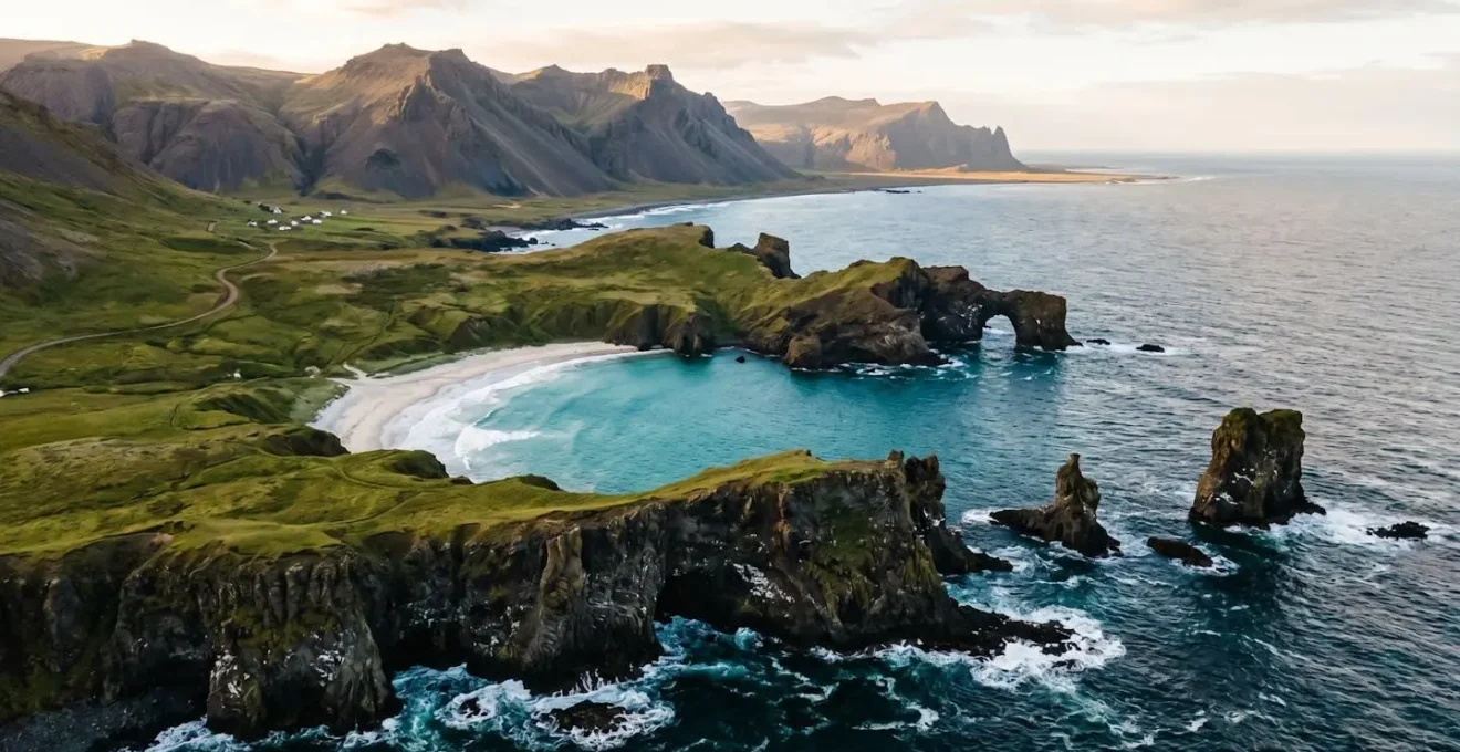
The Coastal Scenery Mistake: Viewing From Roads Instead of Elevated Footpaths
One of the most common mistakes travellers make is confusing accessibility with experience. Driving a coastal road offers a glimpse, but it rarely provides a deep or meaningful connection with the landscape. The true magic of coastal scenery is almost always revealed from an elevated perspective on a footpath. Roads are engineered for efficiency, often cutting through the landscape at low elevations. Footpaths, especially historic ones, follow the natural contours of the land, leading to viewpoints that are physically inaccessible by car.
From a trail perched on a cliff, the landscape unfolds in layers. You see the immediate texture of the path, the endemic plants at your feet, the dramatic drop to the churning sea below, and the distant headlands stretching out into the horizon. This layered perspective creates a profound sense of scale and depth that a roadside pull-off can never replicate. The experience is not just visual; it’s visceral, involving the scent of sea salt and wild herbs, the sound of wind and waves, and the physical sensation of the terrain underfoot. As experts in the Azores note, these trails are the true heart of the islands’ appeal.
Ancient, rugged paths that once bore traders and farmers have been restored to create the official Walking Trails in the Azores, a web of trails that criss-cross the islands, guaranteeing safety and reassurance to walkers.
– Active-Traveller hiking guides, Six of the Best Hiking Routes in the Azores
This principle is vividly demonstrated throughout the Atlantic archipelagos, where centuries-old paths have been repurposed for modern explorers, offering an authentic connection to both nature and history.
The Superior View: Azores Coastal Path Advantage
The Azores archipelago demonstrates the superior coastal viewing experience from elevated footpaths. Trails like the Costa Norte path feature coastal cliffs with protected habitats where constantly shifting scenery between mountains and sea creates layered perspectives impossible to achieve from roads. The iconic fajã descent on São Jorge exemplifies this with lagoon views, steep green cliffs, and Atlantic vistas that compress multiple landscape types through elevation, creating dramatic photographic compression effects and revealing the ‘third landscape’ of trail-edge endemic vegetation.
Choosing to leave the car and commit to a walk, even a short one, is a choice to trade passive observation for active immersion. It is the single most effective way to transform a scenic drive into an unforgettable landscape experience.
When Can You Experience Dramatic Coastal Weather Safely: Storm Watching Without Risk?
The raw power of a storm crashing against a volcanic coastline is one of nature’s most awe-inspiring spectacles. For the landscape appreciator, it’s a coveted experience. However, seeking this drama carries inherent risks, from rogue waves and high winds to landslides on unstable cliffs. The secret to safe storm watching is not to be present during the peak of the storm, but to target the post-storm window. This is the period, typically 2 to 6 hours after a weather system has passed, when the most dangerous elements like wind and lightning have subsided, but the ocean’s energy remains in the form of massive, residual swells.
Planning for this experience requires careful monitoring and a safety-first mindset. On volcanic islands, the risks are compounded. Flash flooding can be amplified by mountainous terrain, and seismic activity can be a concurrent threat. Therefore, preparation is not just about checking the marine forecast; it’s about understanding the island’s unique geological profile. Choosing the right location is critical. You must seek out fortified, elevated positions that were designed to withstand the ocean’s fury, such as lighthouses on high headlands or promenades protected by substantial sea walls. Never stand on an exposed cliff edge or near the water line, as wave behaviour is unpredictable.
By following a clear set of rules, you can position yourself to witness this incredible power without becoming a victim of it. The goal is to be a spectator, not a participant. A disciplined approach allows you to capture the dramatic light and immense power of the post-storm environment while ensuring you have a safe and immediate escape route should conditions change.
- Monitor volcanic and seismic activity first: On geologically active islands, storm risks are magnified. Always check local geological alerts before heading to the coast.
- Target the post-storm window: Plan your visit for 2-6 hours after a storm passes, when swells are large but immediate dangers have decreased.
- Seek fortified coastal viewpoints: Use lighthouses, promenades with high sea walls, or designated storm-watching shelters for observation.
- Apply the 2x wave height rule: Maintain a horizontal distance from any cliff edge that is at least twice the height of the largest observable wave to stay safe from spray and rogue waves.
- Choose locations with escape routes: Always ensure you have a clear, uphill path away from the coast in case of unexpected deterioration in conditions.
How to Access Dramatic Coastal Viewpoints Safely Without Hiring Professional Guides?
While professional guides offer immense value, the independent traveller can safely access world-class coastal viewpoints by leveraging the wealth of infrastructure and information created for organized events and public access. The key is to « piggyback » on official systems rather than venturing into the unknown. Many islands with a strong focus on walking tourism, like those in the Azores or Madeira, have invested heavily in creating safe, well-marked trail networks that are accessible to all.
A highly effective strategy is to utilize the resources of annual walking festivals. The websites for these events often provide a treasure trove of free, professionally vetted trail descriptions, difficulty ratings, and downloadable GPX files. This information remains online year-round, giving you guide-level route quality at no cost. According to current tourism infrastructure data, the Azores archipelago features over 60 marked trails across its nine islands, creating a dense and reliable network for exploration. Focusing on these designated routes is the first principle of safe, self-guided adventure.
Beyond formal trails, several simple strategies can lead you to spectacular and safe viewpoints:
- Use the lighthouse access strategy: Lighthouses are invariably built on dramatic coastal points for maximum visibility. The access roads and paths leading to them are almost always public and well-maintained, offering a safe and reliable route to a guaranteed panoramic view.
- Apply photo geotag triangulation: Use mapping features on photo-sharing apps to find stunning viewpoints captured by other travellers. Then, cross-reference that location on dedicated trail apps like AllTrails or Komoot to find the official, maintained path to get there, complete with recent user reports on trail conditions.
- Focus on designated nature parks: Islands often protect their most sensitive and beautiful coastal habitats within national or nature parks. These parks, such as those on the lesser-known islands of Flores and Corvo, manage access with maintained trails, ensuring both ecological preservation and visitor safety.
By thinking like a strategic researcher and using these existing systems, you can confidently build an itinerary of stunning coastal walks that match your ability level, all without the need for a hired guide.
Atlantic Volcanic Islands or Pacific for Cliff Hiking: Which Has Better Trail Infrastructure?
When it comes to cliff hiking on volcanic islands, both the Atlantic and Pacific regions offer breathtaking trails. However, the quality, style, and philosophy of the trail infrastructure differ significantly, largely due to their unique settlement histories. For hikers who value connectivity, cultural context, and consistent maintenance, the Atlantic volcanic islands generally hold a distinct advantage. Archipelagos like the Azores, Canaries, and Madeira benefit from centuries of European settlement, which created extensive networks of paths for trade and agriculture long before tourism existed.
Many of the premier hiking trails in the Atlantic are converted *levadas* (irrigation channels in Madeira), royal paths, or mule tracks that once connected villages. This historical foundation results in a trail network that is deeply integrated with the cultural landscape, often passing through small hamlets, terraced farms, and offering regular access to amenities. Furthermore, as part of the European Union, islands like the Azores benefit from EU funding and regulations, leading to highly standardized signage, maintenance, and safety protocols across the entire trail system. This creates a predictable and reliable hiking environment. In contrast, Pacific trail systems, while spectacular, can be more varied in their quality and philosophy.
| Infrastructure Aspect | Atlantic Volcanic Islands (Azores, Canaries, Madeira) | Pacific Volcanic Islands (Hawaii, French Polynesia) |
|---|---|---|
| Settlement History | Centuries of continuous European settlement creating extensive networks of levadas, royal paths, and converted mule tracks | Newer infrastructure focused on national park access, with some traditional Hawaiian trails restored in recent decades |
| Trail Philosophy | Village-to-village connectivity through agricultural terraces, offering cultural context and regular amenities (cafés, water sources) | Wilderness or out-and-back trails focused on pure nature immersion, requiring greater hiker self-sufficiency |
| Governing Body | EU-funded, highly standardized signage and maintenance (Azores as part of Portugal benefit from consistent standards) | Varied systems across state and national parks (US Pacific) creating inconsistent trail quality and signage approaches |
| Trail Density | Dense network: Over 60 marked trails across 9 Azores islands, with trails crisscrossing most coastal and interior areas | Concentrated networks: Trails clustered in designated park areas with large undeveloped zones between trail systems |
| Accessibility | High: Ancient restored paths designed for historical commerce, now adapted for tourism with gentle gradients where possible | Moderate: Mix of challenging technical trails and accessible routes, with more extreme elevation changes typical |
| Maintenance Frequency | Regular EU-standard maintenance with organized trail events and annual inspections ensuring consistent condition | Variable: Well-maintained in popular parks, but remote trails may have seasonal accessibility issues |
While Pacific islands offer unparalleled wildness, the Atlantic archipelagos provide a unique blend of spectacular nature and deeply rooted cultural infrastructure, making them a premier choice for hikers seeking a dense, well-supported, and historically rich trail experience.
Key takeaways
- The most scenically diverse islands are often smaller, with a high coastline-to-area ratio and varied geology.
- True landscape appreciation requires leaving the car; elevated footpaths offer superior, layered perspectives that roadside views cannot match.
- Atlantic volcanic islands, benefiting from EU-funded infrastructure and historical paths, generally offer a more dense and consistently maintained trail network than their Pacific counterparts.
How to Find Pristine Island Beaches That Haven’t Been Overrun by Tourism Development?
In an age of over-tourism, the dream of finding a pristine, empty beach can seem like a fantasy. However, by applying a few strategic filters, it is still possible to escape the crowds and find pockets of coastal paradise. The most effective approach is to look for beaches that are protected, either by natural inconvenience or by legal designation. This strategy shifts the focus from « undiscovered » to « intentionally preserved. »
One of the most powerful tools is the 45-minute walk filter. The vast majority of tourists are unwilling to walk more than 15-20 minutes from a parking area. By targeting beaches that require a hike of 45 minutes or more, you automatically filter out over 90% of potential visitors. Often, these pristine coves are just one or two headlands away from a crowded, popular beach. Another method is to use satellite imagery to identify crescents of sand with no visible road access, then research the trails leading to them. The second, and increasingly important, strategy is to target areas with legal protections, specifically Marine Protected Areas (MPAs) and coastal reserves. In these zones, development is legally restricted, ensuring the coastline remains in its natural state.
Case Study: French Polynesia’s Marine Protected Areas Model
French Polynesia demonstrates how Marine Protected Areas can preserve pristine beaches while supporting sustainable tourism. The Gambier Islands serve as a pilot for community-driven conservation with a ten-year plan emphasizing small-scale ecotourism, coral reef protection, and world-class pearl farms. Similar projects across the Tuamotus, Marquesas, Austral, and Society Islands offer visitors curated experiences showcasing thriving marine life and pristine beaches, where locally managed plans ensure commercial development remains legally limited while providing unforgettable travel experiences.
These protected areas are not just good for the environment; they are good for the visitor experience and local economies. As research published by National Geographic Pristine Seas demonstrates, a study of over 50 protected areas found that they consistently boosted either fishing or tourism revenue. By seeking out these well-managed zones, you support conservation efforts while gaining access to the very pristine environments you seek.
Your next journey isn’t just about choosing a destination; it’s about adopting a new way of seeing. Start planning your exploration by identifying these key geological markers and trail systems, and you will transform your appreciation of the world’s most dynamic and beautiful coastlines.