For photographers and nature lovers, the most rewarding islands are not just beautiful, but geologically diverse. The key to finding dramatic cliffs, pristine beaches, and unique rock formations in one place is to understand the volcanic and tectonic stories that shaped them. By learning to read the landscape, you can move beyond simple postcard shots and capture the true, dynamic character of an island’s coastline, transforming your travels and your photography.
As a landscape photographer or an avid nature lover, the quest is always for that perfect destination—one that offers a rich tapestry of scenery without the need for constant travel. You seek an island that provides not just a single, iconic view, but a collection of coastal marvels: towering sea cliffs, hidden coves, volcanic black sand beaches, and tranquil lagoons. The common approach is to pick a famous spot, like Santorini or the Maldives, hoping it delivers. Yet, this often leads to a one-dimensional experience, capturing the same vistas as everyone else.
Many guides will give you lists of beautiful islands, but they rarely explain why they are beautiful or what makes them diverse. They might mention golden-hour photography tips but fail to connect them to the unique opportunities a specific coastline offers. This is where we must shift our perspective. What if the secret to finding the ultimate coastal destination wasn’t just about location, but about understanding the very forces that create these landscapes? The most compelling coastal variety is a direct result of an island’s geological history—a story told in layers of rock, sand, and soil.
This guide abandons the simple « Top 10 » list. Instead, we will act as both geologists and artists. We’ll explore the powerful processes that forge dramatic coastlines, learn how to safely access and photograph them, and ultimately, identify the islands that are living geological storybooks. By understanding the interplay of volcanism, erosion, and tides, you will learn to see the coast not as a static backdrop, but as a dynamic stage, allowing you to anticipate and capture its most breathtaking performances.
This article provides a comprehensive framework for identifying and exploring the world’s most geologically diverse islands. Follow along to transform how you see, experience, and photograph coastal landscapes.
Summary: A Geologist’s Guide to Diverse Island Coasts
- Why Do Volcanic Islands Have More Dramatic Coastal Cliffs Than Coral Atolls?
- How to Access Dramatic Coastal Viewpoints Safely Without Hiring Professional Guides?
- Mediterranean Rocky Coasts or Tropical Palm-Fringed Beaches: Which Landscape Preference for You?
- The Composition Mistake That Makes Coastal Landscape Photos Look Flat and Dull
- When Should You Photograph Coastal Landscapes: High Tide Drama or Low Tide Rock Formations?
- Why Do Volcanic Islands Have Black Sand Beaches Beneath Their Coastal Cliffs?
- The Coastal Scenery Mistake: Viewing From Roads Instead of Elevated Footpaths
- Which Islands Have the Most Spectacular Volcanic Cliffs Accessible for Hiking?
Why Do Volcanic Islands Have More Dramatic Coastal Cliffs Than Coral Atolls?
The dramatic verticality of an island’s coast is written in its geological DNA. Volcanic islands are born from fire and violence. Molten rock builds up from the seabed, creating steep-sided cones. When the sea batters these structures, it erodes the relatively hard, resistant volcanic rock (like basalt), carving out the sheer, imposing cliffs we associate with places like Hawaii or the Azores. The rock’s strength allows it to maintain near-vertical faces against the onslaught of the waves, creating a sense of raw power and scale that is highly photogenic.
In stark contrast, coral atolls are biological creations. They are low-lying rings of coral reef built up over millennia on the submerged flanks of ancient, sunken volcanoes. Their very nature is to be just above sea level. Their geology is made of calcium carbonate—the skeletons of countless coral polyps—which is much softer and more friable than volcanic basalt. Wave action doesn’t carve cliffs; it breaks the coral down into the fine, white sand that forms their iconic, gently sloping beaches. Their beauty lies in their horizontality and color, not their vertical drama.
However, this binary is not the whole story. Tectonic forces can complicate this simple picture, creating dramatic exceptions that prove the rule of geological interplay.
Case Study: Tectonic Uplift on the Huon Peninsula
The Huon Peninsula in Papua New Guinea offers a fascinating twist. While its base is coral, it features dramatic, terraced cliffs. As tectonic plate collisions raise the landmass, ancient coral reefs are lifted far above sea level, creating a series of steep escarpments. This demonstrates that powerful geological uplift can produce cliff-faced coastlines even in non-volcanic settings, reminding us that it is the process—volcanism, uplift, erosion—that dictates the landscape’s final form.
By knowing whether an island is volcanic or coral-based, you can immediately predict the dominant character of its coastline and decide if it aligns with your photographic goals.
How to Access Dramatic Coastal Viewpoints Safely Without Hiring Professional Guides?
The allure of a dramatic cliff edge or a secluded cove is powerful, but the path to these viewpoints is often as challenging as it is beautiful. For the self-reliant photographer and hiker, accessing these locations safely without a guide requires preparation, respect for nature, and an honest assessment of your own abilities. The goal is not just to get the shot, but to return safely with your memories and equipment intact. Relying on marked trails, understanding weather patterns, and carrying the right gear are not optional extras; they are fundamental components of responsible exploration.
The first step is always research. Before you even pack your camera bag, study topographical maps and trail reports. Look for official park trails or well-documented footpaths. Websites, local hiking forums, and apps like AllTrails provide recent updates on trail conditions, closures, and difficulty levels. Pay close attention to comments about erosion, unstable ground, or exposure—all common hazards on coastal paths. Never assume a trail is safe just because you saw a picture of it online. A beautiful photo doesn’t show the slippery mud or the gusting winds just out of frame.
This image perfectly captures the essence of responsible coastal exploration: a prepared hiker, at a safe distance from the edge, appreciating the view with respect.
Notice the essentials: sturdy footwear, a backpack with water and supplies, and hiking poles for stability. This isn’t about fear; it’s about confidence born from competence. True freedom in the wild comes from knowing you have the skills and tools to handle the conditions.
Your Coastal Trail Safety Checklist
- Assess your abilities: Pick a trail that genuinely matches your fitness level and experience with uneven, cliff-side terrain.
- Master basic navigation: Learn to use a map, compass, or a reliable GPS app to avoid getting lost on unmarked or complex coastal paths.
- Race the sun, not the clock: Know the sunset time and plan your hike with a generous buffer; coastal trails often take longer than expected.
- Heed the weather: Be constantly aware of changing weather patterns, as coastal conditions can shift from sunny to dangerously windy and wet in minutes.
Ultimately, the best viewpoint is one you can enjoy without putting yourself or rescue services at risk. Safe exploration leads to better, more thoughtful photography, as it allows you the peace of mind to truly connect with the environment.
Mediterranean Rocky Coasts or Tropical Palm-Fringed Beaches: Which Landscape Preference for You?
The choice often seems binary: do you prefer the rugged, herb-scented drama of a Mediterranean rocky coast, or the soft, sun-drenched allure of a tropical palm-fringed beach? Each landscape offers a distinct mood and set of photographic opportunities. The Mediterranean aesthetic is one of texture, contrast, and history—think ancient stone villages perched above turquoise waters, gnarled olive trees clinging to limestone cliffs, and the sharp, clear light that has inspired artists for centuries.
On the other hand, the tropical preference is about color, softness, and escape. It’s defined by the gentle curve of a white-sand bay, the rhythmic sway of coconut palms, and the vibrant blues and greens of a shallow lagoon. Photographically, this is a world of gentle gradients, warm light, and idyllic compositions. For many travelers, the vacation ideal is one or the other, and they choose their destination accordingly. But for the landscape enthusiast seeking maximum diversity, the ultimate prize is an island that refuses to be categorized.
The most compelling destinations are often those that offer a hybrid experience, blending elements of both worlds. An island forged by complex geology—combining volcanic origins with sedimentary deposits and significant erosion—can provide this « best of both » scenario, satisfying the craving for both rugged adventure and serene relaxation within a single, cohesive geography.
Case Study: Crete as the Ultimate Hybrid Destination
The Greek island of Crete is a masterclass in landscape diversity. It perfectly exemplifies the hybrid ideal for a scenery-focused traveler. Its coastline offers a dramatic spectrum, from the iconic pink sands of Elafonisi beach to the rugged, cliff-bound shores of the southern coast. Inland, dramatic gorge hikes like the Samariá Gorge cut through the mountains, leading from high-altitude terrain down to the sea. These journeys often pass through traditional villages where you can experience the island’s culture alongside its natural beauty. For a photographer, Crete means you can shoot a classic Mediterranean rocky cove in the morning and a wide, sandy beach at sunset, all within a short drive.
Ultimately, the « right » preference is personal, but the savvy traveler knows they don’t always have to choose. Seeking out geologically complex islands like Crete provides a richer, more varied palette for both adventure and photography.
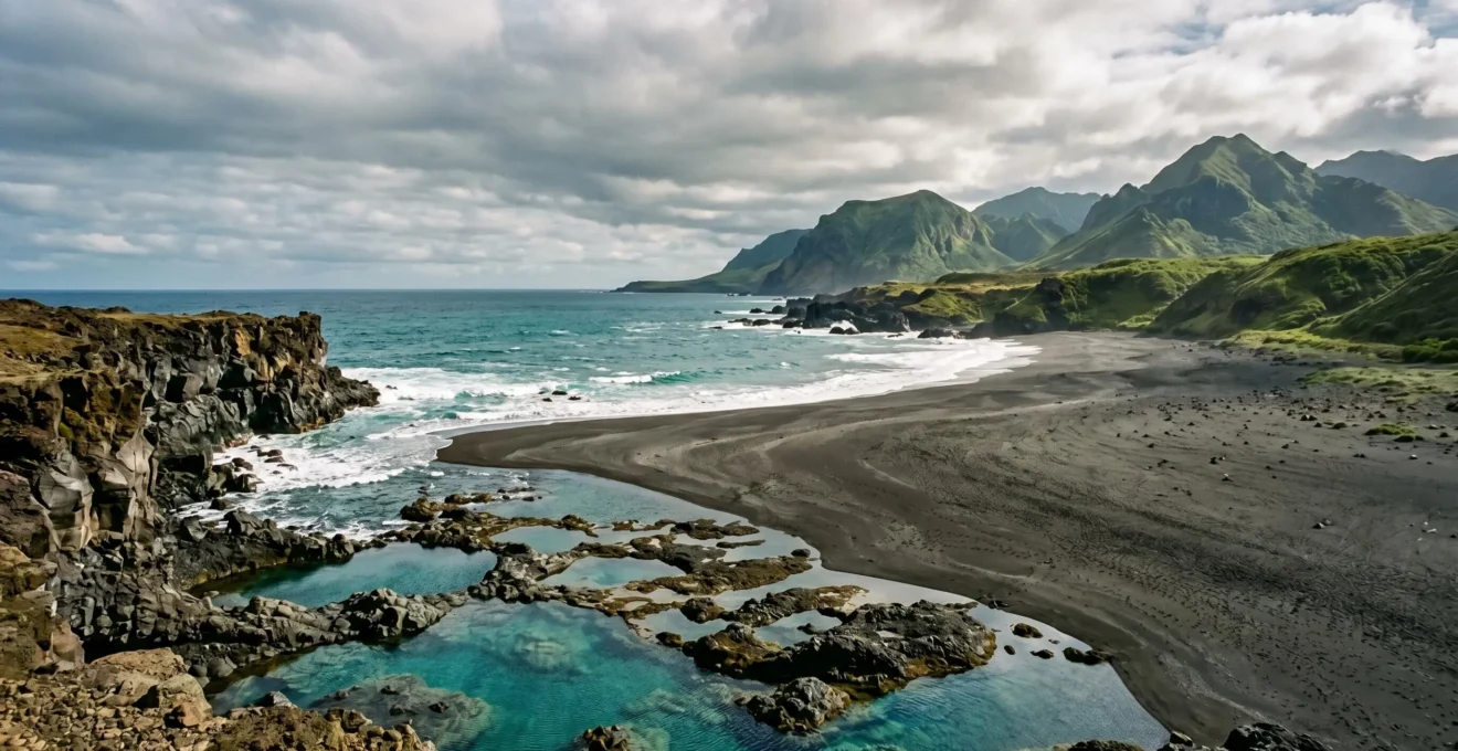
The Composition Mistake That Makes Coastal Landscape Photos Look Flat and Dull
You’ve traveled to a magnificent coastline. The cliffs are towering, the waves are crashing, and the light is perfect. You take the shot, but when you look at it later, it feels… flat. The epic scale you witnessed is gone, replaced by a two-dimensional image that lacks impact. This is the most common frustration in coastal photography. The mistake is almost always the same: a failure to build depth by composing in layers. Many photographers simply point their camera at the most obvious feature—the distant sea stack or the setting sun—and forget everything in between.
A powerful landscape photograph works like a story, guiding the viewer’s eye on a journey through the scene. This requires a clear beginning, middle, and end. In photographic terms, this translates to a compelling foreground, a well-defined midground, and an interesting background. The foreground is your hook; it’s the element closest to your lens that invites the viewer into the frame. On a coast, this could be a textured rock, a reflective tide pool, or the pattern of receding waves on the sand. This is your anchor.
Without a strong foreground, the viewer’s eye is lost in a sea of undifferentiated space, and the image collapses. The key is to think like a geologist as much as a photographer: identify the different zones of the coastal environment and use them to construct your image with intention.
This image is a perfect illustration of the layering principle, creating a powerful sense of Z-axis depth. The foreground is dominated by the sharp, detailed tide pools, their reflections providing an immediate point of interest. The midground captures the dynamic action of a crashing wave, adding energy and a sense of motion. Finally, the background consists of the dramatic cliff silhouette against the sky, providing context and scale. The eye is naturally led from front to back, experiencing the full depth of the scene.
By getting low to the ground and placing your camera near an interesting foreground element—a technique often requiring a wide-angle lens—you can exaggerate this sense of depth and transform a flat scene into an immersive, three-dimensional experience.
When Should You Photograph Coastal Landscapes: High Tide Drama or Low Tide Rock Formations?
For the coastal photographer, the tide is not just a schedule; it’s a creative partner. The rise and fall of the sea completely transforms the landscape, revealing and concealing features, and changing the mood from serene to dramatic. The question isn’t whether high or low tide is « better, » but rather understanding which tidal state will best realize your photographic vision for a specific location. Mastering this « tidal narrative » is as crucial as understanding light. A mediocre location at the perfect tide is often better than a great location at the wrong one.
High tide is the time for drama and power. When the water is at its peak, waves crash with maximum force against cliffs, sea stacks, and man-made structures like piers. This is the moment to capture explosive spray, the raw energy of the ocean, and the tension between land and sea. Using a fast shutter speed will freeze the chaotic beauty of a wave mid-explosion, while a long exposure will turn that same power into a soft, ethereal mist, creating a minimalist composition.
Conversely, low tide is the time for discovery and detail. As the water recedes, it unveils a hidden world. Vast expanses of sand, intricate rock formations, and jewel-like tide pools become accessible. This is the time for exploring sea caves and walking out to sea stacks that are inaccessible at high tide. Low tide is perfect for capturing reflections in the wet sand, the vibrant ecosystems within tide pools, and the leading lines created by water channels draining back to the sea. The light is often softer in the hours surrounding low tide, especially if it coincides with sunrise or sunset.
The optimal tidal conditions depend entirely on the coastal feature you wish to highlight. This is where pre-planning with a tide chart becomes an essential part of your photographic toolkit. An analysis from Oregon State Parks on coastal exploration provides a framework for understanding these relationships.
| Coastal Feature | Optimal Tide Level | Weather Condition | Photographic Result |
|---|---|---|---|
| Sea Caves & Arches | Low to Mid Tide | Calm conditions | Best access for framing and interior details |
| Wave Action on Cliffs | High Tide | High winds or storms | Dramatic spray and power display |
| Tide Pools & Reflections | Low Tide | Calm, post-sunrise/pre-sunset | Mirror-like reflections and marine life visibility |
| Abstract Water Patterns | Mid Tide (transition) | Variable | Dynamic flow through channels revealing/concealing features |
Don’t forget the transitional, or « mid-tide, » periods. This is when water is actively moving through channels and around rocks, creating dynamic patterns and leading lines that are perfect for more abstract or intimate landscape shots.
Why Do Volcanic Islands Have Black Sand Beaches Beneath Their Coastal Cliffs?
The sight of a black sand beach is an otherworldly experience, a stark and beautiful departure from the familiar whites and golds of typical coastlines. This striking phenomenon is a direct and dramatic consequence of an island’s volcanic heritage. The formation of black sand is a story of extreme temperatures, rapid transformation, and the relentless power of the ocean—a perfect example of geological interplay. It all begins when molten rock meets cold seawater.
The primary ingredient in most black sand is basalt, a dark, dense volcanic rock rich in iron and magnesium. When a lava flow from a volcano reaches the ocean, the temperature difference is immense—over 1,000°C for the lava versus around 20°C for the water. This thermal shock causes the molten rock to cool and solidify almost instantly, shattering into countless small fragments in a process known as hydrovolcanic explosion. These fragments range from larger rocks to fine, glassy sand-like particles.
This is just the first step. The newly created volcanic debris, deposited at the foot of the coastal cliffs, is then subjected to the perpetual motion of the waves. Over years, decades, and centuries, the ocean acts as a giant rock tumbler, grinding these fragments against each other, breaking them down further, and smoothing their edges. This constant mechanical erosion is what transforms the shattered basalt into the fine, dark sand that carpets the beach. As one analysis notes, it’s a process of violent creation followed by patient refinement.
The striking black sand was created when molten lava from nearby Mauna Loa or Kīlauea volcanoes flowed into the ocean, rapidly cooled, and shattered into fine basalt fragments.
– Geology In analysis, Top 10 Most Surreal Black Sand Beaches in the World
For a photographer, these beaches offer incredible opportunities. The dark sand creates a stunning contrast with the white foam of the waves, the green of nearby vegetation, or the vibrant colors of a sunset. They are a testament to the raw, creative power of the planet, waiting to be captured.
The Coastal Scenery Mistake: Viewing From Roads Instead of Elevated Footpaths
The classic coastal road trip is an iconic experience, but it often fosters a critical mistake for landscape appreciation: experiencing the coast through a car window. Viewing scenery from a road, even a scenic highway, provides a fundamentally compromised perspective. The viewpoint is low, often obstructed by guardrails or traffic, and the experience is fleeting. You are a passive observer, separated from the environment. The true scale, texture, and grandeur of a coastline are only revealed when you get out of the car and onto an elevated footpath.
Elevated coastal trails, whether they cling to a bluff edge or wind up a nearby hillside, offer a superior vantage point. From a higher perspective, the layers of the landscape become clear: the intricate patterns of the surf, the true color of the water in a hidden cove, and the sweeping curve of the coastline stretching into the distance. This elevated view allows photographers to create compositions with depth and context, showing the relationship between different elements of the landscape. It’s the difference between seeing a single wave and understanding the entire coastal system.
Moreover, footpaths immerse you in the environment. You feel the wind, hear the seabirds, and smell the salt spray. This sensory connection translates into more powerful and authentic photography. The problem, as highlighted in an analysis by Oregon State Parks, is that not all trails are created equal.
Some sections of the trail lack adequate supportive services and facilities, while about 10 percent follows the shoulders of roads and highways, which can feel uncomfortable or unsafe and detract from the hiking experience.
– Oregon State Parks, Oregon Coast Trail Guidelines
This underscores the importance of researching trails that are purpose-built for scenic viewing, rather than simply being connectors along a highway. Ambitious projects like the California Coastal Trail aim to provide exactly this kind of experience. According to the California Coastal Commission, about 70% of the planned 1,230-mile trail is complete, offering hikers access to some of the most stunning vantage points on the continent, far from the noise and limitations of the road.
Key Takeaways
- Geological understanding is key: Volcanic islands offer more dramatic and diverse coastlines (cliffs, black sand) than flat coral atolls.
- Think in layers for photography: Avoid flat images by composing with a distinct foreground, midground, and background to create depth.
- Master the tidal narrative: Use high tide for wave drama and low tide to explore sea caves, tide pools, and rock formations.
Before your next trip, research the network of official coastal footpaths. The extra effort of a short hike is always rewarded with views—and photographs—that are simply unattainable from the roadside.
Which Islands Have the Most Spectacular Volcanic Cliffs Accessible for Hiking?
For the hiker and photographer seeking the ultimate fusion of accessible trails and breathtaking vertical scenery, nothing compares to an island defined by volcanic cliffs. These are places where the earth’s raw power is on full display, and where well-trodden paths allow you to walk along the very edge of creation. These islands offer a multi-day adventure where every turn in the trail reveals a new, jaw-dropping composition of land, sea, and sky. The best destinations in this category are not just defined by their cliffs, but by the quality and diversity of their trail networks.
The Hawaiian island of Kauai is often considered the pinnacle of volcanic cliff hiking. Its legendary Napali Coast is a world-class spectacle, with fluted green cliffs (pali) plunging thousands of feet into the Pacific. The strenuous but rewarding Kalalau Trail offers unparalleled access to this landscape. The Big Island of Hawaii complements this by offering an incredible range of terrain, from coastal cliff paths to the barren, alpine deserts of its massive volcanoes, providing a geological diversity that hiking experts identify as unmatched by any other single island.
In the Atlantic, the Portuguese island of Madeira is another top-tier destination. It is famous for its unique network of « levada » trails. These are irrigation channels carved into the volcanic mountainsides, now serving as relatively flat and accessible hiking paths that traverse through lush subtropical forests and along dramatic cliff edges. This network makes Madeira’s spectacular landscapes accessible to a wide range of fitness levels.
For those seeking a comprehensive list of world-class options, this table provides a starting point for planning your next cliff-hiking adventure, organized by ocean basin.
| Ocean Basin | Island | Signature Trail | Cliff Height Range | Trail Difficulty |
|---|---|---|---|---|
| Pacific | Kauai, Hawaii | Kalalau Trail (Napali Coast) | Up to 4,000 feet | Strenuous |
| Atlantic | Madeira, Portugal | Ponta de São Lourenço | Varied volcanic cliffs | Moderate |
| Atlantic | Azores, Portugal | Coastal paths (multiple islands) | Dramatic coastal cliffs | Moderate to Strenuous |
| Indian Ocean | Réunion, France | Volcanic crater trails | Alpine to coastal range | Strenuous |
| Pacific | Jeju Island, South Korea | Hallasan Summit Trail | South Korea’s highest peak | Challenging |
When selecting your destination, consider not only the drama of the cliffs but also the variety of the trails. Islands like Kauai and Madeira stand out because they offer both epic, challenging routes and more moderate paths, ensuring there is a breathtaking view accessible for every dedicated explorer.