Exceptional water clarity isn’t a matter of luck or location; it’s a predictable science based on geology, ocean dynamics, and your own technique.
- The world’s clearest waters are found over limestone seabeds (like the Caribbean) which act as natural filters, not on islands with high land runoff.
- Predicting peak visibility involves timing your snorkel with neap tides and offshore winds, which minimize sediment suspension.
Recommendation: Master buoyancy control and adopt a horizontal finning technique to avoid disturbing sediment, instantly improving visibility for yourself and others.
For any snorkelling enthusiast, the ultimate prize is water so clear it feels like flying. We’ve all seen the postcards from the Maldives or Bora Bora and dreamt of that perfect, gin-clear visibility. Yet, the reality can often be disappointing: you travel thousands of miles to a supposed paradise only to be met with murky, sediment-filled water where you can barely see your own fins. The common advice is frustratingly vague— »check the weather » or « avoid the rainy season. » But this advice misses the fundamental point.
True, breathtaking visibility that exceeds 30 metres is not found by simply picking a famous island off a list. It’s found by understanding the underlying mechanics of water clarity. The secret lies not in *where* you go, but in *why* the water there is clear. Is it the island’s geology? The local tidal patterns? The time of day you enter the water? The very way you kick your fins?
This guide moves beyond the travel brochure to give you the technical knowledge of a marine visibility analyst. We will dissect the scientific factors that create extraordinary water clarity. You will learn to read the environment like an expert, distinguishing between islands with natural geological filtration and those prone to runoff. We will explore how to use tides, moon phases, and weather patterns to predict the best possible conditions. Ultimately, you will understand that achieving unparalleled underwater views is a skill you can develop, turning the search for clear water from a gamble into a calculated success.
To help you master this skill, this article breaks down the essential components for predicting and finding the clearest snorkelling spots on the planet. The following sections will guide you through the science of water visibility, from large-scale oceanic patterns to the micro-level of your own technique.
Table of Contents: A Guide to Mastering Water Visibility
- Why Are Caribbean Waters Clearer Than the Mediterranean Despite Similar Warm Climates?
- How to Predict Snorkelling Water Clarity Using Weather Patterns and Moon Phases?
- Atlantic Islands or Pacific for Crystal-Clear Waters: Which Ocean Has Better Year-Round Visibility?
- The Fin Technique Mistake That Reduces Snorkelling Visibility by Stirring Sediment
- When Are Island Waters Clearest for Underwater Photography: Time of Day and Season?
- Why Are Some Island Lagoons Crystal Turquoise Whilst Others Are Murky Brown?
- The Reef Snorkelling Timing Mistake That Results in Murky Water and No Visibility
- How to Find Healthy Coral Reefs That Welcome Responsible Snorkellers?
Why Are Caribbean Waters Clearer Than the Mediterranean Despite Similar Warm Climates?
The iconic turquoise clarity of the Caribbean is not an accident of its warm climate. While both regions enjoy warm water, the fundamental difference lies beneath the surface, in their geology and hydrology. The Caribbean basin is geologically distinct, characterized by a foundation of limestone and shallow banks covered in fine, white aragonite sand. This composition is the primary driver of its exceptional visibility. The limestone acts as a giant natural filter, causing rainwater to percolate through the porous rock rather than run off the surface, which drastically reduces the amount of sediment and organic matter washed into the sea. As the Britannica Encyclopedia notes in its oceanographic analysis, the two bodies of water are fundamentally different:
In neither hydrology nor climate, however, does the Caribbean resemble the Mediterranean.
– Britannica Encyclopedia, Caribbean Sea oceanographic analysis
This white aragonite sand, composed of calcium carbonate from corals and algae, creates a second advantage. It doesn’t just settle; it acts as a massive underwater light reflector. Sunlight penetrating the water column hits the bright seabed and is reflected upwards, illuminating the water from below and creating that signature vibrant turquoise glow. This is why even at depths of 10 or 15 metres, the water feels bright and clear. In contrast, many Mediterranean coastlines are extensions of continental landmasses with rivers and surface runoff that carry high loads of sediment and nutrients into the water, leading to higher turbidity and a deeper blue or greenish hue.
This geological distinction is a crucial predictive tool for any snorkeller. Islands built on a limestone (karst) platform will almost always have clearer water than volcanic islands or those connected to large continental river systems, as detailed in the comparative table below.
| Characteristic | Limestone Islands (Karst) | Volcanic Islands |
|---|---|---|
| Rock Porosity | Highly porous, acts as natural filter | Non-porous basalt and volcanic rock |
| Surface Rivers | Rare (water percolates underground) | Common (rainfall runs off surface) |
| Sediment Load | Minimal – filtered groundwater | High – direct runoff carries sediment |
| Typical Water Color | Crystal turquoise (Caribbean, Bahamas) | Variable, often greenish or brown near shore |
| Lagoon Clarity | Exceptional – aragonite sand reflection | Moderate – depends on runoff management |
How to Predict Snorkelling Water Clarity Using Weather Patterns and Moon Phases?
Beyond an island’s geology, water clarity is a dynamic variable governed by daily and monthly cycles of water movement. Predicting visibility is a matter of understanding how tides, wind, and swell affect sediment suspension. The most significant factor is the tide, which is controlled by the moon. The strongest currents occur during spring tides (at the new and full moon), while the weakest are during neap tides (at quarter moons). For snorkellers, this is critical, as oceanographic data reveals that strong tidal currents stir up more sand and silt, drastically reducing visibility. Therefore, planning trips around the quarter moon phases can provide a baseline of clearer conditions.
The second key is timing your snorkel with the daily tide cycle. The period of « slack tide, » approximately one to two hours before high tide, is the golden window for snorkelling. During this time, water movement is at its minimum, allowing suspended particles to settle to the seabed, resulting in maximum clarity. Snorkelling during the run-out tide, or halfway between high and low tide, is often the worst time, as the fast-moving water carries the most sediment.
Finally, weather patterns, specifically wind direction, play a crucial role. An offshore wind (blowing from the land out to sea) is a snorkeller’s best friend. It pushes the warmer, often murkier surface water away from the coast, which in turn causes an « upwelling » of cooler, clearer, and nutrient-rich deep water to replace it. Conversely, a strong onshore wind traps surface water against the coast and creates chop, which churns up the shallows and ruins visibility. Combining these factors allows for a highly accurate prediction of snorkelling conditions.
Your Visibility Prediction Checklist
- Check tide timing: Plan your snorkel for the hour or two leading up to high tide, when water movement is minimal and sediment has settled.
- Monitor moon phases: Prioritize snorkelling during neap tides (quarter moons) and avoid the strong currents of full or new moons, especially halfway between high and low tide.
- Assess wind direction: Look for days with a steady offshore wind, which pushes surface water away and encourages the upwelling of clearer, deeper water.
- Evaluate swell period: Be wary of long-period swells (generated by distant storms), as they create powerful underwater surges that can cloud the water even on calm, sunny days.
- Use satellite monitoring: Before your trip, check free tools like NASA Worldview to spot large-scale sediment plumes from rivers or algal blooms that could affect regional visibility.
Atlantic Islands or Pacific for Crystal-Clear Waters: Which Ocean Has Better Year-Round Visibility?
When comparing the vast expanses of the Atlantic and Pacific, the Pacific Ocean generally holds the title for the clearest open-ocean water on Earth. This is due to the presence of massive « ocean gyres » – large systems of rotating ocean currents – which create vast regions of extremely nutrient-poor, or oligotrophic, water. With few nutrients to support phytoplankton growth, the water becomes incredibly transparent. In fact, a decade-long study using SeaWiFS satellite data found that the clearest oceanic waters on the planet are located in the South Pacific Gyre, near Easter Island and the Pitcairn Islands, with chlorophyll levels below 0.03 mg m⁻³. This makes remote Pacific islands like those in French Polynesia or near the Mariana Islands prime candidates for world-record visibility.
However, this doesn’t mean the Atlantic loses the competition. While its open waters may be more nutrient-rich on average, specific islands in the Atlantic offer some of the most consistent and spectacular visibility in the world due to their unique geology, which can override oceanic trends. The Cayman Islands are a perfect illustration of this principle.
Case Study: The Cayman Islands’ Geological Advantage
The Cayman Islands demonstrate how local geology can create world-class water clarity. The islands are the flat tops of underwater mountains and, crucially, have no mountains or rivers on the surface. This complete absence of land-based runoff means no sediment or silt is washed into the surrounding sea. As a result, the Cayman Islands boast HD-quality underwater viewing conditions year-round, with typical visibility consistently ranging from 18 to 30 metres, and often exceeding that. This shows that while the Pacific may be clearer on a macro scale, a geologically blessed Atlantic island can offer more reliable year-round clarity than a volcanic Pacific island with high rainfall and river outlets.
For snorkellers, the lesson is clear: while the vast, oligotrophic waters of the Pacific offer the *potential* for extreme clarity, the *consistency* of visibility on a given island is more dependent on its local geology (limestone base, no rivers) than the ocean it sits in.
The Fin Technique Mistake That Reduces Snorkelling Visibility by Stirring Sediment
You can find the most pristine, geologically perfect island with ideal tidal conditions, yet still experience poor visibility because of a single, correctable factor: your finning technique. The most common mistake snorkellers make is using a « bicycle kick » or a large, vertical « flutter kick » in shallow water. This motion is highly inefficient and destructive to water clarity. As technical diving analysis confirms, a standard flutter kick directs a powerful jet of water downward on each downstroke. Over a sandy or silty bottom, this instantly kicks up a blinding cloud of sediment, destroying visibility for you and everyone behind you.
The solution lies in mastering two interconnected skills: buoyancy control and proper finning technique. The goal is to achieve neutral buoyancy, where you float effortlessly in the water, and to maintain a horizontal body position known as « trim. » This keeps your body and fins parallel to the seabed, not angled down towards it. From this horizontal position, you should use a « frog kick » or a modified, compact flutter kick that involves small movements from the knee and ankle, keeping the fins elevated and directing water straight behind you, not down.
This mindful propulsion is the hallmark of an experienced and responsible snorkeller. It not only preserves water clarity but is also essential for protecting fragile marine ecosystems. As the experts at Sand Dollar Sports Dive Center emphasize, precise body control is paramount for conservation.
Precise buoyancy allows you to hover effortlessly above fragile corals, grasses, and sea creatures—preventing accidental damage or stirring up sediment.
– Sand Dollar Sports Dive Center, Scuba Diving Buoyancy Guide
By focusing on a stable, horizontal trim and a gentle, efficient kick, you cease to be a source of turbidity. You become part of the clear water environment, moving through it without a trace and preserving the very visibility you came to enjoy.
When Are Island Waters Clearest for Underwater Photography: Time of Day and Season?
For underwater photographers, clarity is everything. Capturing sharp, vibrant images requires not just clear water, but also optimal lighting and minimal water movement. The best time of day is almost universally the morning, ideally combined with a high tide. Morning light is bright but not as harsh as midday sun, which can create distracting « hotspots » and excessive contrast. More importantly, morning waters are typically calmer before the afternoon sea breezes kick in, resulting in a glassy surface that allows for cleaner light penetration. This also means less surface chop, which makes holding the camera steady much easier.
Tidal flow is another critical element for photographers. While slack high tide is excellent, some of the best visibility can occur just before low tide. As the water recedes, it tends to pull suspended particles from the nearshore environment out to sea. In many tropical locations, tidal analysis demonstrates that visibility can improve significantly to 40-60 feet during this pre-low tide window as the water settles and clears. This can be a fantastic, often-overlooked opportunity for photographers.
Seasonally, the best time for photography is always during the island’s dry season. This isn’t just about avoiding rain during your snorkel; it’s about avoiding the consequences of rain, which is land runoff. During the wet season, heavy rainfall can overwhelm an island’s natural filtration capacity, washing soil, sediment, and organic tannins into the lagoons, which can stain the water brown and reduce visibility for days. The dry season guarantees minimal runoff, leading to the most stable and predictable water clarity. A final consideration is the human factor, as highlighted by this practical insight:
Finding Pristine Conditions: The Morning High Tide Advantage
Morning high tide often delivers the most pristine snorkelling and photography conditions for two key reasons: minimal wind and minimal crowds. Before 10 a.m., the water surface is often glassy, and you are far less likely to have to contend with the sediment clouds kicked up by dozens of other swimmers and tour boats that typically arrive mid-morning. This allows for more intimate and undisturbed wildlife encounters, as marine life is less skittish. Getting in the water early is the single best way to ensure you are experiencing the reef at its clearest and most natural state.
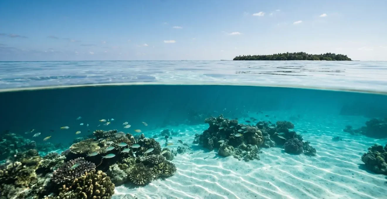
Why Are Some Island Lagoons Crystal Turquoise Whilst Others Are Murky Brown?
The stark contrast between a brilliant turquoise lagoon and a murky, brown one comes down to a simple equation: what flows into the water. The color of a lagoon is a direct reflection of its water source and the geology it passes through. Crystal turquoise lagoons are almost always found on karst (limestone) islands or atolls with no surface rivers. On these islands, rainwater doesn’t run across the land; it soaks into the porous limestone, which acts as a sophisticated natural filter, stripping the water of sediments, tannins, and other impurities before it slowly seeps into the lagoon. The result is pure, oligotrophic (nutrient-poor) water over a reflective white sand bottom—the perfect recipe for vibrant turquoise.
Conversely, murky brown or green lagoons are typically fed by surface rivers and runoff, especially on high, volcanic islands with non-porous rock. When it rains, water rushes over the land, picking up topsoil, agricultural fertilizers, and decaying plant matter (which release brown-staining tannins). This sediment-laden freshwater then dumps directly into the lagoon. The fine silt particles remain suspended in the water column, scattering light and creating a cloudy appearance, while the nutrients from fertilizers can trigger algal blooms that turn the water green.
An extreme example of geologically-filtered purity can be found far from the tropics. In Iceland, the Silfra Fissure contains some of the clearest water on the planet, where geological studies show visibility often exceeds an astonishing 100 meters (325 feet). This is because the water is glacial melt that has spent 30-100 years filtering through miles of underground volcanic basalt rock before emerging in the fissure. It is so pure that it’s essentially mineral water, completely free of sediment or organic matter.
While you may not be snorkelling in glacial water, the principle is universal: the less surface runoff entering a body of water, the clearer it will be. This is why small, low-lying sand cays and remote atolls often have far superior visibility to large, mountainous, and populous islands.
The Reef Snorkelling Timing Mistake That Results in Murky Water and No Visibility
One of the most common and frustrating mistakes snorkellers make is poor timing, leading them directly into murky water despite otherwise perfect conditions. The biggest error is snorkelling at a popular reef during « tour rush hour, » typically between 10:30 a.m. and 1:00 p.m. During this window, dozens of boats and snorkel tours converge on the best-known sites. The sheer number of fins in the water creates a state of perpetual sediment suspension, as the combined kicking action constantly churns up the bottom. No matter how clear the water was at 8 a.m., by 11 a.m. it can be a cloudy mess.
Another critical timing error is misjudging the aftermath of bad weather. Many visitors see that the sun is out and the sea surface looks calm the day after a storm and assume visibility will be good. This is rarely the case. A significant storm or high seas churn up the entire water column, and it takes time for the vast amount of suspended sediment to settle. As experienced divers note, patience is key.
If it were very high seas with churned up bottom, it will take a day or two for the visibility to improve even if the sea is flat the day following the storm.
– DeeperBlue Forums Community, Freediving visibility prediction discussion
A good rule of thumb is to wait at least two days after a major swell or storm before expecting good visibility to return, and sometimes up to a week for the finest silt. To avoid these common pitfalls, a strategic approach to timing is essential.
- Avoid the rush: Plan your snorkel to be in the water before 9 a.m. or after 3 p.m. to avoid the crowds and enjoy the reef in its undisturbed state.
- Mind the tides: Avoid snorkelling on shallow reef flats during low tide. The reduced water column means every fin kick is closer to the bottom, making it easier to stir up sediment.
- Go with the flow: If there is a slight current, plan a « drift snorkel » where you enter the water up-current and let it gently carry you over the reef. This ensures you are always moving into clear water, leaving any sediment you might disturb behind you.
Key Takeaways
- Geology is paramount: Water clarity is primarily determined by an island’s geology. Prioritize limestone-based islands (karst) with minimal surface rivers, as they act as natural filters.
- Clarity is dynamic and predictable: Master the art of timing by snorkelling during neap tides and in the « slack tide » window before high tide to minimize water movement and sediment suspension.
- Your technique is a primary factor: Adopt a horizontal body trim and use a gentle, efficient fin kick to avoid stirring up the seabed. You are personally responsible for the visibility around you.
How to Find Healthy Coral Reefs That Welcome Responsible Snorkellers?
Ultimately, the search for the clearest water is intertwined with the search for the healthiest marine ecosystems. A vibrant, thriving coral reef is a natural water filter and a key indicator of excellent visibility. Healthy corals and abundant fish populations thrive in clean, clear, nutrient-poor water—the very conditions snorkellers seek. The most effective way to find these pristine environments is to seek out well-managed Marine Protected Areas (MPAs). These designated zones, where fishing and other extractive activities are restricted or banned, allow ecosystems to recover and flourish, leading to greater biodiversity and healthier water conditions.
The results of such protections are well-documented. In Cuba’s Gardens of the Queen, a vast no-take marine park established in 1996, the ecosystem has rebounded spectacularly. Recent marine conservation data demonstrates that since protection, fish populations have increased by 30% and shark populations by 10% compared to areas outside the park. This abundance of life is a direct result of the improved health and resilience of the entire reef system.
Seeking out these protected havens, or even less-visited destinations far from the pressures of mass tourism, is a rewarding strategy. It not only leads to superior snorkelling experiences but also supports the conservation efforts that keep these places special.
Case Study: Alor, Indonesia – Pristine and Protected
The Alor archipelago in Indonesia, located in a remote part of the Coral Triangle, is a prime example of a healthy ecosystem delivering world-class conditions. As one of the least-visited destinations in the region, its reefs have been spared the impacts of heavy tourism. This, combined with active protection of the Pantar Strait migratory corridor, has preserved an exceptionally healthy marine environment. Snorkellers here are rewarded with crystal clear waters, with visibility often reaching up to 40 metres (130 feet), and the regular discovery of new, undocumented reefs. Alor proves that the most breathtaking underwater experiences are often found where conservation is a priority.
To find these spots, look for operators with strong eco-credentials, research national parks and marine reserves, and don’t be afraid to venture beyond the most famous names. The reward is not just clear water, but the profound experience of witnessing a truly thriving underwater world.
Now that you are equipped with the knowledge to predict and find clear water, the next step is to apply these principles. Start by researching the geology and tidal patterns of your next potential destination, and commit to practicing low-impact snorkelling techniques to become a guardian of the clarity you seek.